


Sierra Snowpack, Hwy 120 Status
Related: Apple, Apple iOS, Apple iPhone and iPad, Eastern Sierra, Ellery Lake, iOS, panorama, peak bagging, Saddlebag Lake, Yosemite
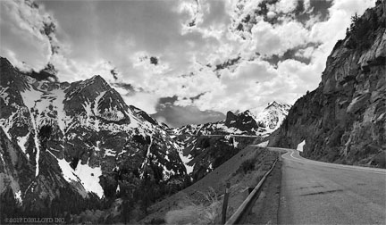
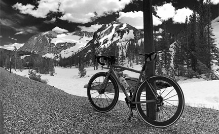
From the east side, plows have reached almost to the Tioga Lake overlook. The ride (or walk) up Lee Vining Canyon is fantastic—clean dry roads with zero cars. I rode up to the end of pavement, which terminated in a 20-foot-deep snowpack just short of the Tioga Lake overlook at about 9700' elevation. I expect by next week the road will be clear to Tioga Pass summit. How the road looks from Olmstead Point to Tioga Pass I don’t know, but I surely would love to ride that whole stretch free of cars—maybe next week just before I return home. The NPS usually takes a lot longer to clear the road (avalanche danger near Olmstead Point due to ice/snow on steep slabby granite), I cannot imagine less than 2 weeks from now, and perhaps 3 or 4.
Most images that follow taken with the iPhone 7 Plus in panorama mode. The iPhone in pano mode is by far the best camera choice for this type of shooting—even off a bike—because one can capture a very wide range of image widths at very good quality up to 17000 pixels wide or so. Downsampled to 50% to 75% linearly, the quality is strong (in pano mode only, still photo mode ranges from marginal to garbage depending on lighting). See iPhone Panoramas In Depth: Shooting & Post Processing Tips, Numerous Examples up to 11K Resolution.
iPhone 7 Plus + iPhone 7 Plus back camera 3.99mm f/1.8 @ 28mm equiv (4mm)
[low-res image for bot]
This bulldozer lower in the canyon is mainly for bashing rocks and small boulders off the road near the highly unstable Blue Slide area—I’ve personally watched it bang rocks off the road for hours during rainy days—BANG, BANG, BANG!

iPhone 7 Plus + iPhone 7 Plus back camera 3.99mm f/1.8 @ 28mm equiv (4mm)
[low-res image for bot]

iPhone 7 Plus + iPhone 7 Plus back dual camera 3.99mm f/1.8 @ 28mm equiv (4mm)
[low-res image for bot]
iPhone 7 Plus + iPhone 7 Plus back camera 3.99mm f/1.8 @ 28mm equiv (4mm)
[low-res image for bot]
One substantial avalanche just below the green bridge and around the corner took out a swath of trees about 80 meters in width, leaving nothing but torn and shredded trees. The road was unscathed.

iPhone 7 Plus + iPhone 7 Plus back camera 3.99mm f/1.8 @ 28mm equiv (4mm)
[low-res image for bot]

iPhone 7 Plus + iPhone 7 Plus back camera 3.99mm f/1.8 @ 28mm equiv (4mm)
[low-res image for bot]
iPhone 7 Plus + iPhone 7 Plus back camera 3.99mm f/1.8 @ 28mm equiv (4mm)
[low-res image for bot]
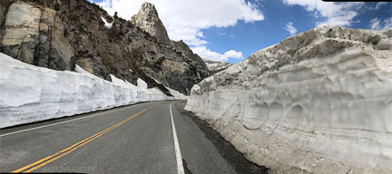
Snow depth varies from two feet to 40 feet, depending on where drifts and windblown areas are found. Towards Tioga Pass (silly me forgot to take a pano there), snow depth seems to be about 10 to 15 feet of densely packed snow that is easy to walk on without sinking at all.

iPhone 7 Plus + iPhone 7 Plus back camera 3.99mm f/1.8 @ 28mm equiv (4mm)
[low-res image for bot]
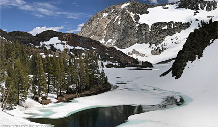
When Ellery Lake Campground opens (late June?), it will be a soggy mosquito-plagued place.

iPhone 7 Plus + iPhone 7 Plus back camera 6.6mm f/2.8 @ 57mm equiv (6.6mm)
[low-res image for bot]
iPhone 7 Plus + iPhone 7 Plus back camera 6.6mm f/2.8 @ 57mm equiv (6.6mm)
[low-res image for bot]
Open water, so it is fishable, but I did not bring a pole.

iPhone 7 Plus + iPhone 7 Plus back camera 3.99mm f/1.8 @ 28mm equiv (4mm)
[low-res image for bot]

iPhone 7 Plus + iPhone 7 Plus back camera 3.99mm f/1.8 @ 28mm equiv (4mm)
[low-res image for bot]
iPhone 7 Plus + iPhone 7 Plus back camera 3.99mm f/1.8 @ 28mm equiv (4mm)
[low-res image for bot]
Snow does not deter insects at all, with ladybugs and bumblebees and beetles all flying about, and the thumping of wild grouse mating calls playing constantly.

iPhone 7 Plus + iPhone 7 Plus back dual camera 3.99mm f/1.8 @ 28mm equiv (4mm)
[low-res image for bot]
Saddlebag Lake road (just out of the picture to the right) to Saddlebag Lake is buried under 6 to 10 feet of snow at the turnoff, and perhaps much more as it approaches the lake. Unless plowing is done, it is not likely to open until late June.

iPhone 7 Plus + iPhone 7 Plus back camera 3.99mm f/1.8 @ 28mm equiv (4mm)
[low-res image for bot]
This is how the snow gets plowed: first a bulldozer plow pushes away the top few feet. Then a bucket dozer takes out big chunks. Then finally an oversize snowplow rig chews up the bottom layer. All three rigs were just below, parked for the holiday. The snow is very firm, perfect for skiing and no postholing when walking. But the sun was intense and did a job on my face, even with sunblock.
The Sony 70-200mm f/2.8 GM delivered numerous severe focusing errors under these conditions (including glitches that prevented MF or AF from reaching infinity focus!), badly damaging this image and making it sharp only at greatly reduced size.

Sony A7R II + Zeiss Batis 135mm f/2.8
[low-res image for bot]

Sony A7R II + Zeiss Batis 135mm f/2.8
[low-res image for bot]
Caught two days prior in a lake reputed to hold large Salvelinus fontinalis I was surprised and delighted by this very large Oncorhynchus clarkii.

iPhone 7 Plus + iPhone 7 Plus back dual camera 3.99mm f/1.8 @ 28mm equiv (4mm)
[low-res image for bot]
Lower elevation lakes are free and clear at 8000' and lower elevations. Lundy lake, below, is at about 7200'.

iPhone 7 Plus + iPhone 7 Plus back camera 3.99mm f/1.8 @ 28mm equiv (4mm)
[low-res image for bot]